The Downs (ship anchorage)

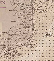
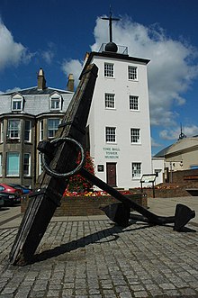
The Downs is a roadstead (an area of sheltered, favourable sea) in the southern North Sea near the English Channel, off the east Kent coast in southern England, between the North and the South Foreland, near the town of Deal. From the Elizabethan era onward the presence of the Downs helped to make Deal one of the premier ports in England, and in the 19th century it was equipped with its own telegraph and timeball tower to enable ships to set their marine chronometers.


The anchorage has depths down to 12 fathoms (72 ft; 22 m).[1] Even during southerly gales some shelter was afforded, though under this condition wrecks were not infrequent. Storms from any direction could also drive ships onto the shore or onto the sands, which—in spite of providing the sheltered water—were constantly shifting, and not always adequately marked. The Downs served in the age of sail as a permanent base for warships patrolling the North Sea and a gathering point for refitted or new ships coming out of Chatham Dockyard, such as HMS Bellerophon, and formed a safe anchorage during heavy weather, protected on the east by the Goodwin Sands and on the north and west by the coast.[2] The Downs lie between the Strait of Dover and the Thames Estuary, so both merchant ships awaiting an easterly wind to take them into the English Channel and those going up to London gathered there, often for quite long periods. According to the Deal Maritime Museum and other sources, there are records of as many as 800 sailing ships at anchor at one time.[3]
In August 1511, Andrew Barton, a privateer, was killed in battle on board his ship. The Battle of the Downs took place here in 1639, when the Dutch navy destroyed a Spanish fleet which had sought refuge in neutral English waters. During the First World War, German destroyers made frequent raids against ships anchored in the Downs. Royal Navy vessels of the Dover Patrol were often tasked with guarding the area at night to discourage the enemy or counter-attack.[4]
The English Channel remains the busiest shipping lane in the world; cross-Channel ferries and other ships still seek shelter in The Downs.[5][6]
Popular culture
[edit]"Black-eyed Susan" or "All in the Downs" is a song by John Gay (1685–1732). The roadstead is also mentioned in the naval song "Spanish Ladies".
References
[edit]- ^ The United Kingdom Hydrographic Office Goodwin Sands/South Sand Head Assessment GS1/2006.
- ^ Robson, Martin (2005). The Battle of Trafalgar. Conway Maritime Press. pp. 29, 36, 158. ISBN 0-85177-979-4.
- ^ Harding, David, ed. (1999). Kingsdown and Ringwould: A History and Guide (3 ed.). Kingsdown and Ringwould Twinning Society. pp. 61–64.
- ^ Buxton, Ian (2008) [1978]. Big gun Monitors: Design, Construction and Operations 1914–1945 (2nd rev. ed.). Barnsley: Pen & Sword. c. 8.4 para. 2. ISBN 978-1-84415-719-8.
- ^ "Maritime Accidents: Pride of Canterbury". Retrieved 8 September 2014.
- ^ "Report on the investigation into the grounding of Pride of Canterbury "The Downs" – off Deal, Kent" (PDF). Retrieved 20 March 2019.
External links
[edit] Media related to The Downs (ship anchorage) at Wikimedia Commons
